
The third Sutton Cycle Forum of 2016 (and the fourth since the borough’s Cycling Strategy was approved in November 2015, and subsequently published in February 2016) took place on 13 September. Unlike the previous forum meeting in June, this time it was the usual format based at the Denmark Road offices of Sutton Council with a starting time of 10am and finishing around noon. The meeting was chaired by Lynn Robinson, and attended by Cycling Champion Cllr. Manuel Abellan (Beddington South); Leigh Gravenor (Kingston Council); Colin and Shirley Quemby (CTC/LCC), John Kinnear (LCC) and Charles Martin (LCC).
Some highlights from this meeting
- Councillor Abellan thought that our request for the addition of a cycling category to the council’s online “Report It” facility was a good idea, and he agreed to help take this forward. This will be very welcome, as the ability to communicate with the council on issues pertaining to the maintenance of cycling features (for example, cycle paths overgrown with vegetation or signage that needs repairing) is not currently straightforward, despite the council’s website having a generic “Report It” area.
- A report, outlining recommended cycling schemes on TfL red routes, has been sent to TfL. Various local committees had agreed in the autumn of 2015 that this be presented to Transport for London, and it is good to know this has now happened. Although funding is not currently available to take ideas forward at this time, it is hoped the report will form the basis of future discussions.
- There are now three engineers, rather than one, involved with cycling across the borough (at least in a part-time capacity). This is very good news! Lynn Robinson will focus on the south-west of the borough, generally the area covered by the Sutton Local Committee and the Sutton South, Cheam and Belmont Local Committee. Two other engineers are working on Beddington, Carshalton, St Helier, Wallington and Worcester Park between them.
- Significant engagement with residents is anticipated well ahead of the full implementation of the borough’s first ‘Quietway’ in 2018, plans for which are continuing to be formulated.
Update on current schemes and ongoing discussions
Scheme updates, and associated items, are given in the order they were presented, and where appropriate headed with the ward name. Some items, which had little direct relevance to cycling, have been omitted. OSM = Open Street Map.
Worcester Park: North Cheam to Worcester Park path (aka Pig Farm Alley) [OSM]. As advised at the June forum meeting, the upgrading of this path is now finished. Direction signs and shared use repeated signs are on order.
Funding for an upgrade to the path that links Pig Farm Alley with Boscombe Road (see photo below) is not available this year. However, an upgrade to the link (to make it suitable for cycling, and give added benefit to the North Cheam to Worcester Park path) is still on the list for attention, and hopefully will be part of the budget for 2017/2018.
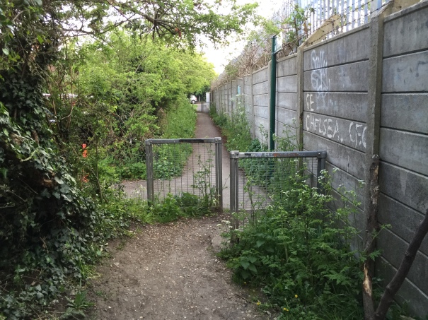
The missing link to Boscombe Road: the path that could be upgraded for cycling in 2017-18
5 May 2016
Funding is to be allocated next year for an upgrade to the path between the stables area (situated at the north-west end of Pig Farm Alley) and Green Lane [OSM]. The LIP Report 2017-2018 (also see below) describes this as follows: “Provide a 3m wide tarmac path 220m long for shared use between pedestrians and cyclists between the end of the tarmac o/s Green Lane School and the turning area o/s Green Lane riding stables”.
The London Borough of Merton is to upgrade the section of path to the north towards Motspur Park [OSM].
These are welcome schemes, but they still tend to suggest that everyone is continuing to do what is relatively easy and non-controversial, while avoiding to address what is required to make cycling an everyday activity on the streets where people live, work and go to school. For the North Cheam to Worcester Park path to ultimately become part of a cycle route linking Sutton with Worcester Park (as apparently is the intention), there will need to be some significant interventions elsewhere along the proposed alignment (notably at the A24 London Road / Stonecot Hill, in Stonecot ward – as described in our recommendations for the Cheam North and Worcester Park Local Committee). The final cost of delivering the Pig Farm Alley path is believed to have been in excess of the funding originally allocated, in part due to the inclusion of fencing at the rear of the properties abutting the path from Conrad Drive.
Sutton North: Angel Hill / High Street / All Saints Road [OSM]. A report has been received back from consultants recommending a shared pedestrian and cycling crossing (ie Toucan crossing) at this intersection. Drawings will be made available in the near future.
As reported in June, the reason for having a Toucan crossing here, linking footways on either side of the High Street, is not clear. This is unlikely to be robust cycling infrastructure!
Beddington South: Woodcote Green [OSM]. The safety audit has now been completed, and this did not highlight any safety issues. Currently working on minor improvements and parking restrictions in the area.
It’s a pity that, for whatever reason, a point closure has not been considered for Sandy Lane South, between Woodcote Green and The Drive. Woodcote Green remains unattractive for cycling. For a reminder of the background to Woodcote Green, see this post from The Alternative Department for Transport (May 2013).
The Wrythe: Green Wrythe Lane (Wrythe Green/William Street to St Andrews Road) [OSM] – footway conversion is nearly complete, some issues coordinating the work with signals. “Nervous cyclists will enjoy cycling here”.
Green Wrythe Lane from Wrythe Green/William Street. The new 80-metre length of segregated cycle path nears completion. The vehicles parked on the unfinished path are believed to be associated with the works related to the lights at the crossing.
13 September 2016
As reported two years ago, this footway conversion is not a cycling facility to be proud of. In fact, it is not a cycling facility at all really. TfL made it clear, early in 2015, that the footway conversion of Green Wrythe Lane to shared-use could not be described as a cycle route. Despite the inclusion of 80 metres of cycle path between William Street and St James’ Road, the changes to the footway along the length of the west side of Green Wrythe Lane are to be classified as a pedestrian scheme. Of course, a very large proportion of the relatively low cycling budget , spread over a number of years, has been spent on delivering (or, perhaps more correctly, not delivering) the Green Wrythe Lane shared-use path.
Wandle Valley: Green Wrythe Lane (Middleton Circle towards Bishopsford Road) [OSM]. A funding allocation is available (presumably from the LIP for the current year 2016-2017) to investigate options for cycling along the section of Green Wrythe Lane between Middleton Circle and Bishopsford Road (phase 4). We were told that this northern section of Green Wrythe Lane would not include shared use footway, “unless people want it”.
A real concern is that if sub-standard cycling schemes (such as footway conversion to shared use) continue to be devised in the borough, the likelihood of Sutton being awarded any worthwhile or significant funding for cycling infrastructure (as and when this becomes available) will be seriously diminished.
The Wrythe / St Helier: Although not reported at the meeting, it was around this time that bollards appeared along Green Wythe Lane (phase 3 – between Fellowes Road and Middleton Circle [OSM]) on the west side footway indicating, that the footway was for shared use.
Wandle Valley: Peterborough Road/Bishopsford Road [OSM] Sustrans are in the process of removing the NCN signs here, now that the route through Poulter Park is in place (and it was noted that parts of the Wandle Trail in Poulter Park are overgrown with vegetation due to a general lack of maintenance). The issue regarding people parking vehicles across the access to the cycle path link (first reported here two years ago), and how to resolve this, has dropped down the agenda. The reason given is, annoyingly, that the NCN route has been rerouted through Poulter Park. Nevertheless, we have always said that this does not reduce the need to resolve the issue with the cycle path link at Peterborough Road because people will still be cycling here, and cycling provision needs to be inclusive. There is some promising news though, because the same type of issue will need to be resolved at Newstead Walk (St Helier ward) [OSM] as part of the borough’s first Quietway. The designs for Newstead Walk could potentially be used at Peterborough Road too. Additionally, the borough’s Parking Strategy is on its way (see the Environment and Neighbourhood Committee 15 September 2016 meeting page).
Nonsuch / Worcester Park: Nonsuch Park to Worcester Park signing will be done soon (think we were told that last time)!
Cycle stand locations
- Worcester Park: still waiting to hear from St Anthony’s Hospital [OSM], having had a promising first discussion with the facilities manager. Will be chased-up again. St Anthony’s Hospital is one of the venues used for Cheam North and Worcester Park Local Committee meetings.
- The Wrythe: Bikehangar request near Denmark Road [OSM] – going to formal consultation in two weeks. [Subsequently noted consultation period 22 September to 13 October]
If you would like the council to consider installing a Bikehangar where you live, it is recommended that you contact your ward councillors in the first instance to try and get support.
Report for TfL
The TfL report summary has been sent informally to the council’s liaison officer at TfL.
It not sure when, what format the report took, or whether it mentioned that ideas for Rosehill roundabout had been rejected.
The response to the report from TfL was, not unexpectedly, that there is currently no funding for cycling infrastructure on TfL roads in the borough.
It is, however, hoped that the submission of the report to TfL will give an indication that Sutton has an interest in delivering meaningful cycle schemes (albeit only on TfL roads at present), as and when future funding becomes available.
Members of the Beddington and Wallington Local Committee will be updated on this, as this committee had shown a particular interest in the ideas for TfL roads in their committee area (and it is on the Tracker). The council will try and instigate a meeting with TfL to discuss further.
There is the expectation that options and schemes for TfL roads across the borough will remain on the agenda.
At the Croydon Cycle Forum on 8 March 2016, under an item entitled Strategic Plan for Cycling Schemes, a presentation was given by Hal Bransby on the question ‘how to tie all the different cycling projects in Croydon into a strategic plan’. A key element of this strategic plan was the framework of two key cycle routes in Croydon, north to south, and east to west (the A232), with a hierarchy of routes from super highways to greenways. (It was noted, though, that the most important priority to get mass cycle usage was to provide the best possible conditions for short cycling journeys e.g. to school, work, etc., for people of average fitness and ability). Hal was present at the Croydon Cyclists monthly meeting yesterday (12 September 2016), and Charles Martin mentioned the a report that Sutton Council was sending to TfL included ideas for the A232. It’s important to keep cross-borough contact!
Also awaited (expected this autumn), which could have implications for the A232, an update from TfL on the Fiveways Croydon consultation.
Sutton Town Centre Masterplan | London Cancer Hub
The Housing, Economy and Business Committee had approved the the revised masterplan for the redevelopment of the town centre at their meeting on 21 June 2016. Sutton Newsroom | Housing, Economy and Business Committee.
Not convinced that cycling is seen as a real opportunity here. For background on this, see Sutton Town Centre draft Masterplan consultation.
Royal Marsden (London Cancer Hub) [OSM] – still with Development Control, and discussions around this and new secondary school (and demand for school places) are still underway.
Sutton Council’s Housing, Economy and Business Committee subsequently approved the Development Framework for The London Cancer Hub, which aims ultimately to become the world’s leading life-science campus specialising in cancer research, treatment, education and enterprise, at their meeting on 27 September 2016. Sutton Newsroom | Housing, Economy and Business Committee.
In the short term, improvements to the Cotswold Road, Chiltern Road and Brighton Road intersection (Belmont ward) are anticipated. Difficulties here were highlighted in The idea for space for cycling on Brighton Road gathers support (December 2015).
LIP schemes 2016-2017
Belmont: Overton Park [OSM]. Construction of shared-use path, linking Overton Road with Chipstead Close, started last week and expected to take four weeks to complete.
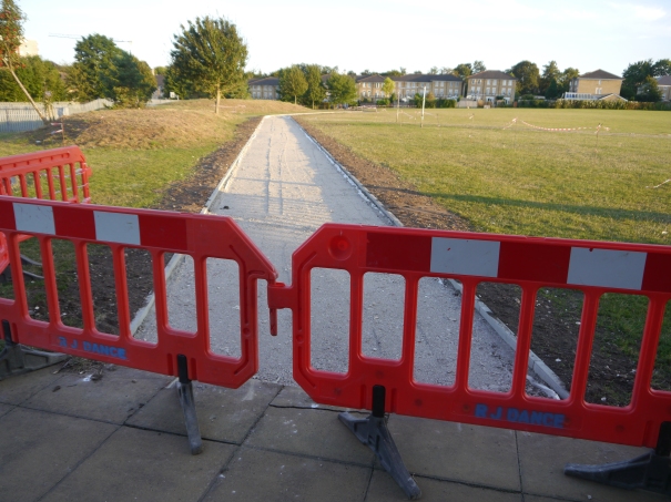
The new path in Overton Park taking shape
14 September 2016
The issue regarding the gated status of this park (especially at Moore Way [OSM]), and the idea that paths through this park can be describes as forming a cohesive route, was again raised by us (and there is more on this in Ideas for boosting Sutton’s cycling aspirations – also see below). It was reassuring to hear that alternative options for the Moore Way entrance/exit (hopefully with open, inclusive, access (as discussed for Peterborough Road above) will be considered. Of course, the topic of inclusive access (or lack of) on branded “cycle routes” applies at various other locations too, notably Sustrans route 208 at Reigate Avenue Recreation Ground [OSM].
Carshalton Central: Ruskin Road parallel crossing (linking the southern end of path (by ornamental gardens, The Square, Talbot Road) with Carshalton Park) [OSM]. Currently at the design stage. Consultation on this will follow when the plans are finalised.
This is a far cry from our Carshalton Central Space for Cycling ‘ward ask’, requesting the removal of through motor traffic on the “quiet” residential roads surrounding Carshalton Village. But at least a parallel crossing, rather than a shared crossing, is proposed for Ruskin Road.
Carshalton Central: Mill Lane crossing (by Butter Hill) [OSM]. At design stage, consultation to follow.
Not quiet sure what this is. But the volume of traffic on Butter Hill, especially at the southern end by London Road and Manor Road North where the road narrows [OSM] and which forms the LCN route 75, has been a contentious issue for many years and remains unresolved.
Beddington North: Beddington Lane (B272) [OSM]. A 20 mph zone for Beddington Village [OSM] is coming soon. Beddington Lane, at £3million overall (down from £15million), is a “major scheme”….
…but not major enough – certainly when it comes to cycling. The B272 has been known to carry more traffic (with a high proportion of HGVs) than the parallel A237, so a 20mph zone in isolation is unlikely to make a huge amount of difference. For more on this, and some major ideas for Beddington Lane and the village that could actually enable cycling, see A cycle tour of Beddington Village.
Worcester Park / Nonsuch: A 20mph zone around Cheam Common Road and Balmoral Road in the vicinity of Cheam Junior School [OSM] is proposed.
A large part of the Worcester Park ward, north of Central Road, has been subject to a 20mph speed limit for a number of years. It would seem sensible to extend this to the rest of the ward in one phase, rather than continue, as here, with a piecemeal approach. When Thornton Road (St Helier) became 20mph, in about 2012, more new 30mph signs seemed to appear than 20mph signs (simply because all the side roads remained at 30mph and signs were required to delineate the transition . [Google Streetview].
Traffic counts
A request was made, once again, for the details of the traffic (cycle) counts, carried out during March 2016, to be made available if at all possible. Cllr. Abellan will follow up.
LIP programme 2017-2018
The Local Implementation Plan (LIP) is the current mechanism whereby Transport for London allocate money to the London boroughs to spend on projects which support the Mayor’s Transport Strategy.
“Promoting active modes and modal shift, including cycling, is an important aspect of Sutton’s Local Implementation Plan”. London Borough of Sutton Cycling Strategy, November 2015
The eight items listed below have been taken from the “Local Implementation Plan (LIP) for the 2017-2018 budget” report, Appendix A, 15 September 2016, prepared ahead of the Environment and Neighbourhood Committee on 15 September 2016, under the section headed “Cycling Schemes”. The document had not been in the public domain prior to the Cycle Forum meeting on 13 September, but a copy was made available at the meeting.
The September LIP report details the process whereby the listed schemes had been presented to members of the local committees during June and July 2016 for consideration, and the resultant issues raised. Nine schemes had been discussed at the June Forum meeting (through the report “Local Implementation Plan Funding 2017/18” that was being sent to the local committees at the time – which, in the case of the Sutton Local Committee, had been dated 7 June 2016). The noticeable missing scheme in the September document, compared to those from late spring early summer, is a contra-flow for Link Lane, Wallington.
- Bridge Road, Wallington [Wallington South] [OSM]
- Sutton Common Park [Sutton North] [OSM]
- Nonsuch Park [outside London]
- Green Lane [Worcester Park] [OSM]
- Roundshaw Downs Greenways [Beddington South] [OSM]
- Wallington North/South Cycle Route [Wallington North] (Don’t get too excited – reference to this “route” currently just relates to “allowing cycling on the footway of A232 Croydon Road between Bute Road and Beddington Park”. This insubstantial intervention here does not give much confidence that the full potential to establish an inviting cycle route, parallel to Woodcote Road, will ultimately be delivered)
- Camden Road contra-flow [The Wrythe]
- Middleton Road [Wandle Valley]
Of these, the three we would like to see prioritised are:
- Camden Road, Carshalton [The Wrythe]: contraflow [OSM]
- Roundshaw Downs [Beddington South]: Greenway link [OSM]
- Bridge Road/Clarendon Road/Ross Parade, Wallington [Wallington South]: improvements at junction [OSM]
All three of these schemes formed part of the ‘ward ask’ for the wards in question (The Wrythe, Beddington South and Wallington South).
In the case of the contraflow (adjacent to the Harris Junior Academy Carshalton), it will be necessary to make changes to the existing parking arrangements in Camden Road for this to be facilitated (not just new signs, as presented in the description given in the LIP 2017-2018 report). Parking on the north side of the street will almost certainly need to be removed, and the possibility of using spare “capacity” for parking in Hollymead needs to be explored. The crossing build-outs are likely to need re-engineered too, and changes will be required at the junction with West Street / Wrythe Lane.
The Camden Road contraflow was briefly talked about at the St Helier, The Wrythe and Wandle Valley local committee on 7 July 2016 (as part of the LIP presentation agenda item). From reading the minutes, and then listening to the recording, it was obvious there was some confusion about this. Furthermore, the borough’s cycling strategy was not mentioned during the discussion. This point was made to Cllr. Abellan at the Cycle Forum, because it is important. Councillors are making decisions now, that may have an impact long into the future. It is important that they are fully conversant with the approaches the council has set out. Had someone taken the opportunity to mention the cycling strategy (or the sustainable transport startegy, or the parking strategy, or the emerging health and wellbeing strategy), whilst talking about the cycle contraflow, then this would have indicated a wider understanding of the issues. Potentially, a lost opportunity.
There was some uncertainty about Roundshaw Downs (to be discussed at the next Beddington and Wallington committee on 11 October 2016).
The final funding for the LIP 2017-18 is still not known. LIP submissions usually in October, so announcement expected soon. London elected a new Mayor on 5 May 2016, and the three-year spending programme was coming to an end.
There will be more on the LIP programme for 2017-2018, in our anticipated forthcoming post Sutton Cycle Funding 2017-18 (to complement Sutton Cycle Funding 2016-17 and Sutton Cycle Funding 2015-16).
Worth reminding ourselves a this point that our main priorities for the “big money” (so, beyond the LIP) remain as detailed in our press release at the time of the Space for Cycling petition handover on 21 July 2015 (and again discussed in May 2016):
- Make Sutton town centre more accessible by bicycle, with a focus on removing the severance caused by the gyratory system (Sutton Central ward)
- Introduce a trial closure of some residential streets close to the centre of Carshalton village to through traffic in order to increase their viability for cycling (Carshalton Central ward)
- Develop a network of safe routes to five schools situated on busy roads in Beddington South (Beddington South ward)
- Provide a trial of light segregation on heavily trafficked roads that form part of the National Cycle Network and the Avenue Verte in Carshalton and Wallington (Wallington North)
Quietways
For background to this, see our report from the Quietway ride, part of the cycle forum June meeting: Sutton’s proposed first Quietway: what is required to make it a success?
Sutton Council met with TfL recently to discuss the borough’s first Quietway (Sutton to Morden). The meeting was very positive, and a slightly revised upward funding allocation of £1.4 million is to be made available (shared between the two boroughs concerned, Merton and Sutton). Sustrans expect delivery over two or three years, although TfL would like to see some progress in 2017/18. Ward councillors (presumably those representing St Helier, Sutton North and Sutton Central) will be visiting the proposed route in coming weeks.
What can be expected? At the moment, proposals include a controlled crossing at Bishopsford Road (A217, a very busy road) to link Malmesbury Road (LB Merton) with Newstead Walk (LB Sutton); resurfacing of Stavordale Road and Lindores Road; a parallel crossing for Wrythe Lane (between an extended path alongside Robertsbridge Road and the path through Rosehill Park East). Expect a better interface between Rosehill Park East and Rosehill Park West / Grennell Road. Build-outs/pinch-points will be removed (some have already been removed on Grennell Road apparently). Speed cushions are to be replaced by sinusoidal humps. Sustrans have undertaken traffic counts (as have we – they are (too) high on Grennell Road, especially between All Saints Road And Edinburgh Road) around 8.15 on a school-day morning). Mini-roundabouts, or crossroads? Discussions ongoing. The route may start and finish in Sutton High Street by Trinity Square, rather than at Lodge Place, (subject to discussion with town centre management) to celebrate the fact that (courteous and considerate) cycling is permitted in Sutton High Street.
The main thing is, there will be an engagement exercise (rather then just a public consultation) with residents to give everyone the bigger picture.
Expected timeline (under review):
- consultation review by June 2017
- consultation September 2017
- construction from summer 2018
The two to three-year timeframe is quite good in some ways. As we said in Quietways require more than lines and signs (September 2015), it is better to do things properly rather than rush the process. Discussion with residents in areas surrounding the route (and not just on the route alignment) will be paramount. Consultation need to be set in the context of what is trying to be achieved (ultimately working to reduce stress on parking, provide better streets, reduce rat-running, and make healthy and active travel an inclusive transport option for many more local journeys).
The route will provide, in theory at least, ‘quiteway’ status along the complete alignment between Sutton town centre and the centre of Morden. However, it is disappointing that there are no planned links to St Helier Hospital or the David Weir Leisure centre (even though the alignment will pass within a few hundred metres of both). (It is even more intriguing to note, therefore, the plans in the 2017-18 LIP programme to provide a cycle path link, 240 metres in length, between Sutton Common Park pavilion and Sustrans route 208. Useful yes, but considerably less useful than a dedicated cycle link between a high-profile Quietway route and a major employment centre or leisure centre).
There is also concern that the path through Rosehill Park East (Greenshaw Wood) may be shared-use, rather than having a defined path for cycling (as is currently the case). There are going to be ongoing discussions about this, but shared-use is believed to be Sustrans recommendation at the moment (and LB Merton are deploying shared-use on parts of the route as well). More in a forthcoming post.
It will be necessary to make improvements at the Manor Lane, Throwley Way (gyratory), Lodge Place intersection. Improvements here are all part of the idea of cycling hubs in town centres from three or four years ago, the borough’s 2013 mini-Holland bid, and the Space for Cycling ‘ward asks’ (June 2014).
It is clear that ‘Quietway’ status is not compatible with the existing traffic volumes, and so ways of dealing with this will need to be explored. The option of using retractable bollards on Edinburgh Road, for example, in order to prevent rat-running may be an option to be considered. If residents, living within a specified area, were provided with a transponder to activate the bollards, and so still have access to all areas, the idea could be more appealing. Transponders could also be made available to those driving emergency vehicles, council vehicles, and buses. 20 mph speed limits, although very welcome, will not be the silver bullet. They will certainly need to be area-wide.
Maintenance of routes
Upkeep of cycle routes and cycling infrastructure is a continuing concern. This summer, for example, trees have overgrow paths and have not been trimmed back (which has the potential to increase the risk of collisions). Pot holes, damaged signs and cycle stands, gravel and rubbish left on the paths, are the sort of issues that occur all year. Currently, there is not a way of easily reporting these issues to the council. A request was made to have a way of reporting cycling maintenance issues on the council’s website. Councillor Abellan thought that our request for the addition of a cycling category to the “Report It” facility was a good idea, and he agreed to help take this forward.
The Cycling Strategy (November 2015) made it quite clear that maintenance would be reviewed, looked at, and put to the top of the agenda. There is little evidence, yet, that this is actually happening. It is hoped that a “Report It” facility can be delivered prior to the first annual review of the strategy, to demonstrate the council’s commitment to this agenda.
Idea’s for boosting Sutton’s cycling aspirations
Idea’s for boosting Sutton’s cycling aspirations (August 2016) gave four examples of the sort of baseline ideas that need to be embraced if the borough is to move forward and begin to deliver the aspirations set out in last year’s Cycling Strategy. The examples given were categorised as:
- Start to replace cycling infrastructure that fails to impress
- Recognise that a cycle path through a park does not necessarily make a cycle route
- Review schemes, and address what does not work
- Make the most of opportunities when they are presented
There was a short discussion about this. Hopefully, the message has been heard. One or two short term outcomes from this may be a reassessment of the Overton Park gate at Moore Way [Belmont], and a discussion at committee about Woodcote Road [Wallington South].
AOB
Felnex redevelopment [Wandle Valley] – no news, disccussions ongoing.
Tharp Road [Beddington South] [OSM: cycle layer]. Residents of Tharp Road are requesting that their street be considered for conversion to one-way operation. This request is believed to be due to difficulties for passing traffic, in this heavily parked-up street. If so, one-way working would solve the difficulty that motorist are experiencing for sure. However, Tharp Road, forms part of a signed, east-west, cycle route, that enables cyclists to avoid using the busy Croydon Road, A232, to the north, or the equally busy Stafford Road, B271, to the south. Consequently, the introduction of one-way traffic on Tharp Road would potentially have a very negative impact on cycle movements in this part of the borough. There will be more on this at the Beddington and Wallington Local Committee on 11 October 2016. And talking of one-way streets…..
Stone Place [Worcester Park] [OSM: cycle layer] It looks as though Stone Place (currently one-way in from Central Road) will convert back to two-way at some point in the relatively near future following pressure from local residents. It is certainly under review. The introduction of one-way here, without allowing access by bicycle in the opposite direction, was a bad decision when originally taken a few years ago as part of the outer London fund programme. Doesn’t anyone cycle to Waitrose? Probably not.
Notes to other forum meetings (from 2016 onwards) available at Sutton Cycle Forum.
v2: 11.11.2016

Merton Cycling Campaign is keen to be involved.
Thanks Charles. Look forward to working more closely with you too.